Holidays, domestic duties, work, accidents and caring for accident victims meant that just three of us made the trip to the English Heritage site and the upland grassland that surrounds it.

The views from the car park would have been stunning on a clear day. Unfortunately it wasn't! Even so there was a good view to the south west.
 |
| Photograph: Jim Cresswell |
The minority were more hardy and set out onto the hill.
When the rain had stopped the softies who had retreated to the car to avoid a slight wetting followed the advance party who now cut a lonely figure on the near horizon.

The stragglers joined him and spent a little time looking for things in the grass before heading for the stone circle.
First you pass some ramparts which are no more than 18 inches high. Nowhere near high enough to deter a marauding band. But it was explained to me that erosion would have lowered their height as would collapse into the associated ditches.
At last we arrived at the circle. If you had come here expecting a version of Stonehenge you would have been sorely disappointed. About half of the stones have disappeared, the result of ancient damage, according to the information board, not recent pilfering, and most of the rest are quite short above ground.

The most impressive is about 6 foot tall.

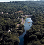
As in the car park on a clear day the views would have been exceptional. But as I wrote earlier, it wasn't and it was raining again (hence the blobs on the above photograph). There was a good view of Corndon Hill and Lan Fawr just over the border in Wales

And of the west of Shropshire with Wales beyond.

After paying homage to one of the stones by kneeling by it and searching the bordering vegetation for spiders we decided to head down the path that descends into the valley in the centre of the above photograph seeking shelter from the strong biting wind.

We found a sheltered spot and had an early lunch.
It started to rain again and a decision to call it a day or carry on was required. We carried on. And grudgingly the weather relented and granted us a few warm sunny periods which made us shed all the extra layers we had put on when we got out of the car.
At the side of the path we found a nettle that had been galled by Puccinia urticata causing the stem to buckle.

 |
| Photograph: Jim Cresswell |
Thyme was very common here and can be seen at the base of the rock in the following photograph.
 |
| Photograph: Jim Cresswell |
 |
| Photograph: Jim Cresswell |
 |
| Photograph: Jim Cresswell |
The sky was darkening and it was obvious more rain was due. We returned to the car arriving about 10 seconds after the start of the threatened shower.
Time to go home.
My thanks to Jim Cresswell for sending me some photographs to use in the report.


No comments:
Post a Comment
Please feel free to comment on this post...